Mahlon Joseph Bourgeois
July 7, 2009
Ronnie Jerome Labit
July 9, 2009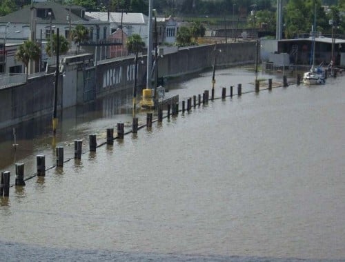
The U.S. Corps of Engineers is looking for 25 million cubic yards of borrow material to increase levee protection along the Atchafalaya Basin.
Senior Project Manager Marti Lucore said although the proposed work is ongoing throughout a seven-parish reach, most of the project will focus on levee protection in West St. Mary Parish, south of U.S. Highway 90.
“We need thick, clay earth that compacts well, prevents seepage and allows us to fill in places that have sunk – which is a good many areas – in addition to raising or elevating areas in other places,” Lucore said.
Interested landowners are asked to contact Thomas Parker, environmental resource specialist with the corps, at (504) 862-2526.
Lucore said the corps can acquire borrow material from approved sources within the continental United States; however, they prefer borrow sites in close vicinity to the Atchafalaya River Basin.
Before any borrow material can be used for levee construction, soil-boring tests must first be completed. If the soil passes muster, pertinent environmental clearances are then sought, he explained. The whole process can take six to nine months – and that is contingent upon the material being deemed suitable, Lucore said.
Work on the Verdunville area levee protection system was recently completed, Lucore said, but work on the west side of the basin is ongoing.
Lucore said the most recent work is separate from the Franklin Canal closure project. The government is studying how it will close off rising storm surges along St. Mary Parish’s coast.
“With the little federal money we receive, it is a lot easier to build miles of levees and to reinforce levees than to perform a closure project,” she said. “We’re told the project in Franklin requires a closure mechanism. Our projects are really levee elevation. We’re building up what erosion has taken away south of U.S. Highway 90.”
“There is nothing we’re doing that’s going to stop the flooding from the Franklin Canal,” she added. “What we are doing, however, will give control to any backwater flooding south of U.S. Highway 90.”
Lucore said Hurricane Ike caused flooding over U.S. Highway 90, forcing officials to close the highway from Verdunville west to Franklin.
“I don’t know if what we’re doing will stop that in the future, but it will definitely help,” she said.
The Atchafalaya River serves as a catch basin, of sorts, for the Mississippi and Red rivers. The three water bodies meet in Simmesport, La.
At Congress’s behest, the corps began regulating how much Mississippi River water feeds into the Atchafalaya. The waterway’s strength, coupled with gravity, naturally forces the Mississippi River to detour, providing a shorter path to the Gulf of Mexico.
The corps controls the waterflow with a gate system – the Old River Control Structure – allowing only 30 percent of the Mississippi and Red rivers to flow into the Atchafalaya.
Lucore attributes advancements in flood protections from keeping these waters at bay in St. Mary Parish.
Between Morgan City and the Town of Berwick, there are 15 miles of 22-foot tall levees along the river.
“You noticed about a month ago, the river was high,” Lucore explained. “This primarily was from the spring thaw up north. As you could have seen by looking at the river’s rising levels at that time, those levees serve as great protection for both Morgan City and Berwick.”
The Atchafalaya River reached nearly 7 feet in Morgan City at its peak in June. The river had been predicted to crest at 6 feet. * Photo by HOWARD J. CASTAY JR.

